佃島・月島について/About Tsukudajima and Tsukishima
はじめに
月島は明治期後半、19世紀末から東京湾の埋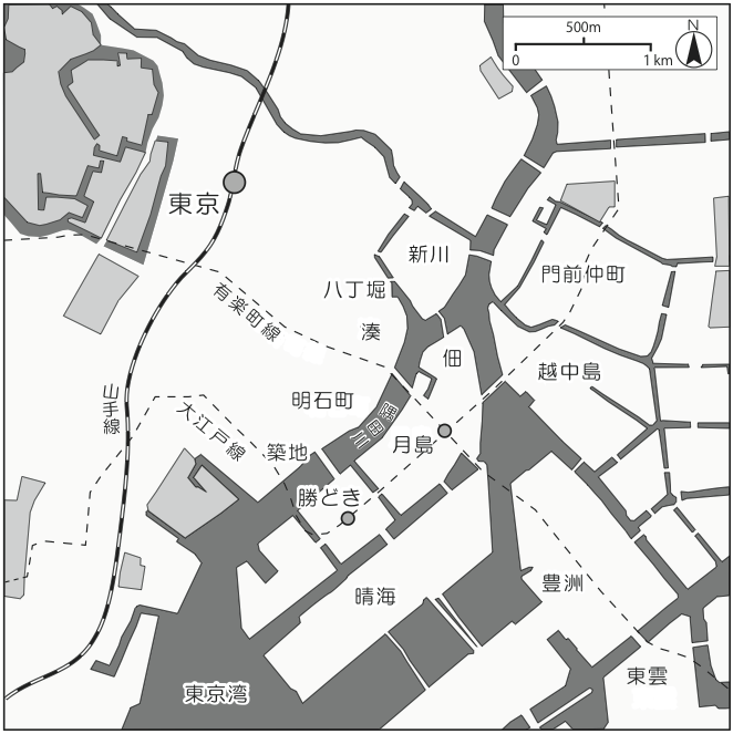 め立てによって作られた隅田川河口の人工島です。埋め立ては石川島造船所の本拠地となった石川島と、江戸初期から続く歴史的な漁師町である佃島の延長上に行われました。月島は20世紀初めの産業発展の拠点であり、近代日本初の都市計画から生まれた町です。東京湾の埋め立てはその後も続き、月島に隣接して勝どきや新佃島が、さらに沖合の晴海や豊洲、東雲が埋め立てられました。
東京という都市は、江戸時代の火災や地震、1923年の関東大震災、太平洋戦争中の東京大空襲などにより、何度となく壊滅と復旧を繰り返してきました。戦後数十年の開発によって、佃島と月島は劇的な変化をとげましたが、昔ながらの景観や暮らしぶりを守り続けています。
Introduction
Tsukishima is situated at the mouth of the 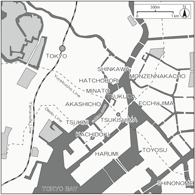 Sumida River, built on land reclaimed from Tokyo Bay in the late nineteenth century. The reclamation merged to form a larger island with Ishikawajima, home of Ishikawajima Shipyard, and Tsukudajima, an island with a history going back to fisherfolk who settled there in the seventeenth century. Tsukishima was a hub of industrial development in the early twentieth century and the product of modern Japan’s earliest efforts at urban planning. Reclamation projects continued in Tokyo Bay, creating the neighboring districts of Kachidoki and Shin-tsukudajima, and further expanded outward to form Harumi, Toyosu, and Shinonome.
Tokyo was destroyed and rebuilt many times over the course of its history, ravaged by fires and earthquakes during the Edo period (1603–1867) and in 1923 and devastated by air raids during the Pacific War. Development in the postwar decades has changed Tsukudajima and Tsukishima dramatically in some ways, while preserving the old townscape and way of life in others.
歴史 History
石川島
江戸幕府の船手頭(ふなてがしら)であった石川八左衛門正次(まさつぐ)が、1626年に「鎧島」と呼ばれていた無人島を幕府から屋敷地として与えられました。現在の大川端(おおかわばた)リバーシティの三井不動産によるタワーマンション群が林立するあたりです。石川八左衛門正次は怪力の持ち主でした。それにまつわる興味深いエピソードが「石川島資料館」に展示されています。
日本橋から鉄砲洲のあたりが、当時の幕府海軍基地だったため、この石川島は屋敷地ですが、幕府海軍の前線基地と位置づけられました。現在の新川に「霊岸島(れいがんじま)水位観測所」が設置されたのは、江戸時代から、そのあたりが江戸港の中心だったからです。島にはいくつかの堀があったようであり、それらは船を停泊させておく「船入堀(ふないりぼり)」だったと考えられます。
「鬼平犯課帳」で有名な長谷川平蔵の進言によって1790年につくられたとされる人足寄場(にんそくよせば)は、石川島の南にあった葭沼(よしぬま)を造成してつくられました。現在の佃公園の池や遊具があるあたりに相当します。
Ishikawajima
The area where the Ōkawabata River City 21 high-rises stand today was an uninhabited natural island originally called Yoroijima (Armor Island). In 1626, theTokugawa shogunate bestowed the island on Ishikawa Hachizaemon Masatsugu, who had been appointed funategashira (official in charge of the maritime andnaval affairs). Masatsugu was the heir of Ishikawa Ōsumi-no-Kami Shigetsugu, a member of the inner circle of stalwart retainers of first shogun Tokugawa Ieyasu (1543–1616), and Yoroijima came to be known as Ishikawajima. The full set of samurai armor on display at the IHI Ishikawajima Museum is said to have been wornby Masatsugu’s father.
During the Edo period, the center of maritime and naval affairs was locatedbetween the mercantile center of Nihonbashi and the bayside Teppōzu, and Ishikawajima probably served as a naval outpost. When modernization began in the Meiji era (1868–1912), the official observatory for monitoring the water levelof the bay was established in Reiganjima (now Shinkawa, northwest of Ishikawajima across the Sumida River). Ishikawajima was accessed by a number of canalsthat were probably used for harboring boats.
As part of the late-eighteenth-century Kansei Reforms led by shogunal senior councilor Matsudaira Sadanobu, the swamp on the southwest side of the islandwas reclaimed, and in 1790, became the site of the ninsoku yoseba, a facility for rehabilitating criminals. The idea behind this project had originated with a member of the shogunal police force named Hasegawa Heizō, who has since become a popular hero portrayed in fiction and television dramas.
佃島
1630年、摂津国(現在の大阪)佃村を中心とした漁師らが、石川島の南の干潟百間四方を幕府から貰い受けました。漁師たちは漁の合間に昼夜休むことなく島を造ったと言われており、1644年に造成が完了しました。
島は、大小二つの部分がつくられ、その間が船入堀です。現在もそれは船入堀として使われており、漁師町の面影を残しています。
現在はカミソリ堤防があるので分かりづらいですが、江戸の町を正面として町が構成されています。月島地区の氏神様である住吉神社は江戸の町、江戸城があった方向、摂津国の方向を向いています。田の字型の街割りにおいて、住吉神社側の街区が「上町」で、隅田川寄りの方が敷地割りが大きくなっています。祭りの時の幟の建て方も、江戸の町から見て扇形に広がるように見えるように配置されています。
Tsukudajima
In 1612, Tokugawa Ieyasu brought to Edo a group of fishermen from the village of Tsukuda in what is now Osaka (then Settsu province), with their advanced fishing techniques, and they were appointed special purveyors of fish to Edo castle. In 1630, the fishermen were given a large expanse of tideland flats (100 ken square, or about 33,100 sq m) to the southwest of Ishikawajima, which they were free to reclaim and settle. The fishermen worked night and day whenever they were not fishing to build Tsukudajima, the island that became their home in 1644.
Tsukudajima’s community leaders lived in large-size plots on the Sumida River side of Uwate, the northern half of the island, where Sumiyoshi Shrine is located. The harbor inlet dividing the island in two is still used today, preserving the ambience of the old fishing settlement.
The people of the original Tsukuda village in Osaka, so legend goes, were loyal to Ieyasu and put their maritime and other knowledge behind his forces during his battles in Osaka against the continuing resistance of the heir of the previous ruler, Toyotomi Hideyoshi. So when Ieyasu began to build the new “eastern” capital in Edo, he called on the fishermen of Tsukuda to move to Edo, where they enjoyed the protection of the shogunate and received special fishing privileges. When they built their community, they showed their respect by designing it to face Edo castle. The torii gate of Sumiyoshi Shrine is located on a straight line to where the castle once stood, although the view is blocked today by the high levees. At festival time, the banners are raised in a fan shape, the better to attract attention from the city across the river.
月島
東京の近代化以降に最初につくられた埋立地です。1887年に着手された埋立は、大幅に縮小された東京港築港計画の一環であり、隅田川の澪浚いを兼ねていました。埋立の完了は1892年と言われており、その年に東京市区改正委員会で月島の街路計画が審議されていることから、我が国初の近代都市計画である市区改正計画によって誕生したことになります。
第一次世界大戦が始まった頃までに、多くの工場や倉庫が建設されました。そこで働く労働者のための住宅が大量に必要になり、現在も残っている路地と長屋群がつくられていきました。西仲通り商店街は、石川島にあった造船所と月島3丁目にあった石井鉄工所の間に形成されたものです。
1896年に埋立が完了した新佃島の東側は、かつて風光明媚なことから別荘地でした。
Tsukishima
Tsukishima was the result of the first land reclamation project undertaken during the Meiji era, after Edo was renamed Tokyo. It was part of a grand plan to transform Tokyo into a modern city and to construct Tokyo Port in conjunction with the dredging of the Sumida River. Although the Tokyo Port plan was greatly scaled down, construction of Tsukishima was completed in 1892. One year before completion, in 1891, the Tokyo City Planning Council worked on the layout of the streets of Tsukishima, making the design of the district the first incidence of modern urban planning in Japan.
From then until the beginning of World War I, many factories and warehouses were built on Tsukishima. The town as it is today was gradually built as housing was put up for the many workers of these factories. The Nishinaka-dōri shopping street was built along the line between the Ishikawajima Shipyard on the east end and the Ishii Ironworks at the west end. The residential blocks flanking the shopping street are packed with small, two-story dwellings called nagaya (rowhouse), each facing a narrow street called a roji (alley).
Shin-Tsukudajima, an extension of Tsukudajima, was reclaimed in 1896, following the street plan of Tsukishima. The area along the east side offered a fine vista of the bay and the Bōsō peninsula and became the location of second residences of members of the wealthy class.
路地と長屋と生活 Alley,Nagaya and Life
路地と長屋
佃島の路地は、狭い島の中に住宅が詰め込まれるように建っているため1m程の幅しかありません。元々島は、住吉神社を除いて計35筆に分割し宅地化されました。それが人口増加と共に密集して住宅が建てられるようになり、しだいに路地がつくられていきました。奥行き20間程の街区の長手方向に、4〜5間を単位として路地と住宅がつくられています。路地からの各住宅への入口は南側にあり、建物の北側にはなるべく窓をつくらないという慣習があります。
 佃島は、関東大震災の時も焼失しませんでした。隅田川を越えて飛んできた火の粉を、住民が結束して消火したと伝えられています。路地は非常に狭いので、今でも「バケツリレー」での消火訓練が行われています。
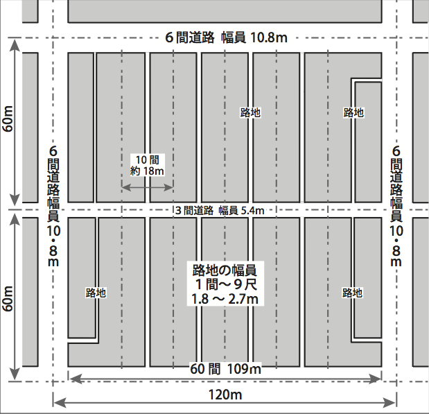
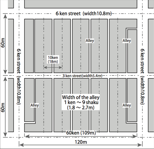
月島の路地は、佃島の路地以上に規則的につくられています。近代都市計画でつくられた島ですが、その街割りは江戸期に見られた「一町街区」(約120m四方)を基本単位として街割りされました。道路部分を除くと、一つの街区の大きさは60間となります。更に正方形の街区を二つに分割する3間道路がつくられました。この街区の大きさは、工場や倉庫を建設するにはちょうど良かったが、宅地には大きすぎました。そこで街区の長辺方向を6つに分割し、短冊状になった敷地割りの中央に路地を通し、両側に長屋が建設されていきました。路地の幅は1間から9尺で、これは当時の法律によるものです。路地は50m程の長さがあり、その1本あたり24軒程の長屋が建ち並んでいます。
長屋の標準的な間口は、1住戸あたり2間で、奥行きは3.5間程です。2軒から4軒長屋が多くつくられました。1住戸あたりの床面積は44㎡程と狭いが、1階と2階を別に賃貸することや、更に2階を二つに分割して賃貸することが多かったといわれています。
Streets and Rowhouses
Land was precious on the small island of Tsukudajima, and the streets were laid out to pack in as much housing as possible, leaving many of the alleys less than a meter wide.
Initially, when the fishermen’s reclamation work was completed, the whole island except for the precincts of Sumiyoshi Shrine was divided up into 35 rectangular residential units. As the population increased, the dwellings grew dense, solidifying the layout of the town. As we can see today, each unit is 20 ken (36.4 m) deep, divided by alleys and housing sites in 4–5 ken (7.28–9.10 m)-wide blocks. The entrance end of each dwelling faces an alley on the south. The custom is to have few windows on the north end of the houses.
 While most of Tokyo was reduced to ashes in the 1923 Great Kantō Earthquake, Tsukudajima did not burn. The residents banded together to prevent the sparks flying from across the Sumida River from starting fires on their side. The side streets dividing the houses are very narrow so bucket relay drills for firefighting in emergencies continue to this day.
The layout of Tsukishima is even more regular than that of Tsukudajima. The town may have been designed by modern urban planning, but the basic units follow the “1-chō gaiku” block (about a 120-meter square, or 14,400 sq m) that was the standard during the Edo period. Each block of 60 ken (about 109 m) on a side (excluding the street width) was divided into two parts, by a cross street 5.4 meters wide. That half-block size was good for factories and warehouses but too large for housing. So those parts were subdivided into six long-narrow sections intersected by narrow 2–3 meter-wide alleys following the laws of the time, with rowhouses built facing alleys on both sides. Each alley was about 50 meters long, so there were about 24 rowhouses clustered along both sides of each alley.
The rowhouses consisted of two to four units joined by common walls, and the standard size of one rowhouse unit was 2 ken (3.64 m) wide and 3.5 ken (6.37 m) long (extending back from the street). A one-unit house was very small, its two-story floor area only 44 square meters, and often a family would live on the first floor and rent out the second floor as one or two separate units.
長屋の生活
長屋は壁が薄く、家々が密集し、 生活は隣近所に筒抜けでプライバシーがほとんどありません。トイレは各戸にあったものの、風呂場を作るスペースはなく、住民は銭湯に通っていました。この地区にはかつては銭湯がたくさんあったのです。近隣にお店が多く、台所が手狭であったため、住民は出来合いの惣菜を配達させることも度々あり、食事処や居酒屋が増えました。こういうものすべてが長屋文化として、外界から切り離された緊密なコミュニティを作り、歴史と地続きの文化、昔ながらの伝統にもとづく暮らしぶりが残されています。
Life in the Nagaya
Nagaya residents got used to living in very close quarters, where the walls were thin and there was no space between houses. There was hardly any privacy, and everyone knew what everyone else was doing. There were toilets in each rowhouse unit, but no space for individual baths, so everyone went to the public bathhouses, of which there once were quite a few. With shops close by and kitchens cramped, people often ordered food delivered, and the number of eateries and drinkeries increased. All this became part of the culture of the nagaya neighborhoods, secluded pockets of tight-knit communities that give a sense of history and retain a way of life based on old traditions.